The question I researched was, where are good locations in Wisconsin to put a cabin? I wanted to find a location for a cabin that was in a forested area, within 2 miles of a Wisconsin park, within 1 mile of a Wisconsin river, at least 3 miles away from a Wisconsin major highway, and at least 15 miles away from a Wisconsin major city. My intended audience is a person who wants to build a cabin in a quiet location surrounded by nature in Wisconsin and is looking for the right location, I am suggesting locations that matched certain criteria. People who are interested in building a cabin would use this information to locate a spot they want to build a cabin, they could then take this information to look further into purchasing this land to build a cabin there.
Data Sources:
The data I needed for this project were datasets for states, parks, rivers, cities, major highways, and forests. I got all of my data except for the forest dataset from Esri 2013 database. I got a county forest dataset from the WI DNR 2014 database.
The only concerns I have with my data sources are, what criteria was used to constitute a park or a forest in the datasets I used. The WI DNR has their classification methods, but I do have concerns with the completeness of the dataset. Almost all of the forests in this dataset lie in northern Wisconsin, but I know there are forests in southern Wisconsin as well. Same goes for the parks dataset. The dataset claims to include local parks, not just state and national, but I have concern that not all parks in Wisconsin are included in this dataset. My results would be different if there were different classification methods for parks and forests for the datasets.
Methods:
The methods I used to find land areas for possible cabin locations are highlighted in the data flow model below in Figure 1. I first had to download my datasets from the databases. Next I set all of my data sources to my study area, Wisconsin. After I did that, I was able to analyze the data to answer my spatial question of where to place a cabin in Wisconsin. I used the spatial tools of dissolve, intersect, select by location, clip, erase and buffer. I used intersect to find the land areas that contain all of the features I wanted in a cabin location, and I used erase to remove from that land area the land that contained features I did not want in my cabin location. I utilized the dissolve tool to remove internal boundaries within my feature class polygons, to clean up my datasets. I used the buffer tool to find land areas within specified distances of features.
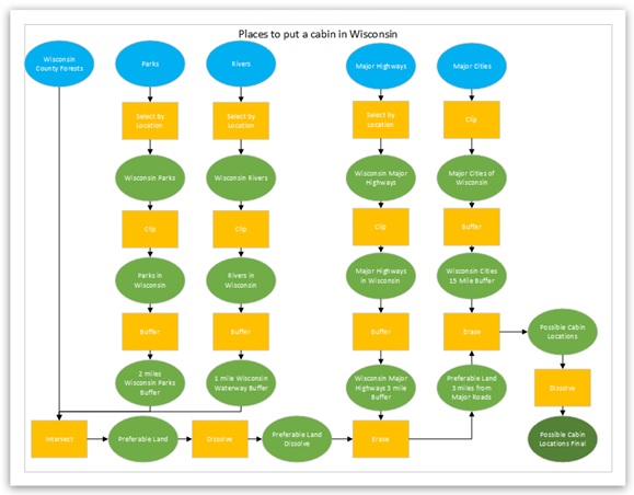
Figure 1
Results:
My project resulted in land areas that match the criteria for a cabin. The locations are located in a forested area, within 2 miles of a park, within 1 mile of a river, at least 15 miles away from a major city, and at least 3 miles away from a major highway. These locations fall mostly in northern Wisconsin. There are numerous locations in Wisconsin that match the cabin requirements. Possible cabin locations fall within 23 different counties in Wisconsin.

Figure 2
Evaluation:I enjoyed this project, it helped visualize things spatially by being able to construct my own project and gather my own datasets. If I were asked to repeat the project I would start by looking at a dataset that shows land that is available for development. The locations I found that match my criteria for a cabin I have no idea what is already there. There might already be a cabin there or some other development, or even farm land. Also I wanted my cabin location close to natural features, so there is a chance that the locations that match my criteria fall in a protected wildlife area where a cabin would not be allowed to be built. To change this problem I would find a dataset that shows non developed land in Wisconsin, or property for sale and then build my search for the land areas that match my criteria for a cabin location on those land areas. This would help my project be more specific and a person who wanted to build a cabin could give an exact location they want to build, knowing that land area is available. The only challenge I faced when completing this project was I originally wanted to use population as a variable. I wanted to have possible cabin locations in areas with low populations, but I had difficulty determining a proper dataset and didn't want my project to be overwhelmed with too many variables. I deemed this variable unnecessary in determining cabin locations. I modified my project to not include population data.
No comments:
Post a Comment