Wednesday, May 11, 2016

Lab 4: Mini-Final Project

Introduction:
The question I researched was, where are good locations in Wisconsin to put a cabin? I wanted to find a location for a cabin that was in a forested area, within 2 miles of a Wisconsin park, within 1 mile of a Wisconsin river, at least 3 miles away from a Wisconsin major highway, and at least 15 miles away from a Wisconsin major city.  My intended audience is a person who wants to build a cabin in a quiet location surrounded by nature in Wisconsin and is looking for the right location, I am suggesting locations that matched certain criteria.  People who are interested in building a cabin would use this information to locate a spot they want to build a cabin, they could then take this information to look further into purchasing this land to build a cabin there.    

Data Sources:
The data I needed for this project were datasets for states, parks, rivers, cities, major highways, and forests.  I got all of my data except for the forest dataset from Esri 2013 database.  I got a county forest dataset from the WI DNR 2014 database.    


The only concerns I have with my data sources are, what criteria was used to constitute a park or a forest in the datasets I used.  The WI DNR has their classification methods, but I do have concerns with the completeness of the dataset.  Almost all of the forests in this dataset lie in northern Wisconsin, but I know there are forests in southern Wisconsin as well.  Same goes for the parks dataset.  The dataset claims to include local parks, not just state and national, but I have concern that not all parks in Wisconsin are included in this dataset.  My results would be different if there were different classification methods for parks and forests for the datasets. 

Methods:
The methods I used to find land areas for possible cabin locations are highlighted in the data flow model below in Figure 1.  I first had to download my datasets from the databases.  Next I set all of my data sources to my study area, Wisconsin.  After I did that, I was able to analyze the data to answer my spatial question of where to place a cabin in Wisconsin.  I used the spatial tools of dissolve, intersect, select by location, clip, erase and buffer.  I used intersect to find the land areas that contain all of the features I wanted in a cabin location, and I used erase to remove from that land area the land that contained features I did not want in my cabin location.  I utilized the dissolve tool to remove internal boundaries within my feature class polygons, to clean up my datasets.  I used the buffer tool to find land areas within specified distances of features.    
Figure 1

Results:
My project resulted in land areas that match the criteria for a cabin.  The locations are located in a forested area, within 2 miles of a park, within 1 mile of a river, at least 15 miles away from a major city, and at least 3 miles away from a major highway.  These locations fall mostly in northern Wisconsin.  There are numerous locations in Wisconsin that match the cabin requirements.  Possible cabin locations fall within 23 different counties in Wisconsin.
Figure 2
Evaluation:
I enjoyed this project, it helped visualize things spatially by being able to construct my own project and gather my own datasets.  If I were asked to repeat the project I would start by looking at a dataset that shows land that is available for development.  The locations I found that match my criteria for a cabin I have no idea what is already there.  There might already be a cabin there or some other development, or even farm land.  Also I wanted my cabin location close to natural features, so there is a chance that the locations that match my criteria fall in a protected wildlife area where a cabin would not be allowed to be built.  To change this problem I would find a dataset that shows non developed land in Wisconsin, or property for sale and then build my search for the land areas that match my criteria for a cabin location on those land areas.  This would help my project be more specific and a person who wanted to build a cabin could give an exact location they want to build, knowing that land area is available.  The only challenge I faced when completing this project was I originally wanted to use population as a variable.  I wanted to have possible cabin locations in areas with low populations, but I had difficulty determining a proper dataset and didn't want my project to be overwhelmed with too many variables.  I deemed this variable unnecessary in determining cabin locations.  I modified my project to not include population data. 

Wednesday, May 4, 2016

Lab 3: Vector Analysis with ArcGIS

Goal:
The goal of this lab is to perform a vector analysis in ArcGIS using certain geoprocessing tools to identify a fitting habitat for bears in the location of Marquette County in Michigan.    

Background:
The purpose of this mapping exercise is to locate a suitable habitat location for bears in Marquette County, Michigan.  I determined what forest types bears were found in and if they prefer to be located near streams.  I then determined where suitable bear habitat locations were in DNR management lands.  I also found the DNR bear habitat lands that were 5 kilometers away from urban or built-up lands.      

Methods:
Task 1
I first needed to determine what type of data I was working with.  I opened ArcCatalog and explored the data for this lab.  I had to determine what type of files I was working with and what coordinate systems were being used.  I determined that my main source of data, bear_locations_geog$,  was an excel file and used map X Y coordinates.  I next opened are map and added this data to the viewer.  I did this by selecting the File heading from the main interface and choosing Add Data: Add XY Data.  I selected to import the file bear_locations_geog$.  I set the X Field to POINT_X and the Y Field to POINT_Y.  I left the Z field displaying <None>.  I selected the coordinate system to be NAD 1983 HARM Michigan GeoRef (Meters) and imported the file.  Once the file had loaded and the points were mapped in the ArcMap viewer I exported them and added them to the lab's geodatabase (Marquette_bear_study.gdb) as feature class.       

Task 2
In the ArcMap viewer I added all of the other feature classes within the bear_management_area feature dataset to the data frame, bear_management_area feature class and the Political_boundaries feature class.  I arranged the layers in an order optimal for viewing and symbolized the landcover layer to have unique values based on the "minor type" field.  I performed a Spatial Join with Bear Locations and Landcover.  I summarized the Minor Type field in my new feature class's attribute table to find how many bears were found in each habitat.  The top 3 habitat types were Mixed Forest Land, Forested Wetlands, and Evergreen Forest Land.

Task 3
I wanted to find if rivers had an influence on bear locations.  I performed a 500 meter buffer of the rivers feature class and performed an intersect between the outputted buffer and bear locations to determine how many bears were located within 500 meters of a river.  After performing a summarize of the ID field of the outputted feature class, I determined that 49 of the 68 bear locations were located within 500 meters of a stream.  That is equivalent to 72% of bear locations are within 500 meters of a stream making it a suitable criteria for bear habitat locations.   

Task 4
I extracted my suitable landcover types for a bear habitat as a new feature class and intersected them with the stream buffer to find suitable areas for bear habitat.  I removed the internal boundaries in my new feature class by performing the Dissolve tool.   

Task 5
I needed to determine the locations of bear habitat on the Michigan DNR management lands.  To do this I first clipped the DNR management lands feature class to the study area.  I then used the overlay tool Intersect to determine the locations where the bear habitat and the DNR management lands were both present in the study area.  I performed the dissolve tool on the output feature class to remove internal boundaries.    

Task 6

I now needed to exclude DNR management lands with bear cover that are within 5 kilometers from Urban or Built up lands.  To do this I extracted the Urban or Built up lands as a new feature class from the Landcover feature class by Selecting by Attributes MAJOR_TYPE='Urban or Built-Up Land'.  I performed a buffer of the Urban or Built up land areas of 5 kilometers.  I performed an erase between the buffer of Urban or Built up land cover and the DNR land bear habitat area.  My output was bear habitat landcover that is within DNR management lands and is not within 5 kilometers of Urban or Built up lands.          

Task 7
I created a map highlighting my results of Tasks 1 through 6. I also created a data flow model of my work flow.  Images of both can be found in the Figures section below, Figure 1 and Figure 2. 

Task 8
This task's purpose was to practice the use of ArcGIS Python with some basic information. I wrote python commands for a buffer analysis, an interest analysis, and an erase analysis.  A screen shot of my python code can be found in the Figures section below as Figure 3. 

Results:
The results that appear on the map show that bears tend to be located near streams.  The bear population also tends to lie outside of the DNR bear habitat lands.  The bears also tend to lie more inland in the Michigan peninsula.     

Figures:
Figure 1


Figure 2

Figure 3

Sources:

"Michigan GIS Open Data." GIS Open Data State of Michigan. MI.gov, n.d. Web. 30 Apr. 2016.

 "Michigan 1992 NLCD Shapefile by County." Michigan 1992 NLCD Shapefile by County. N.p., 06 Nov. 2002. Web. 30 Apr. 2016.

"Wildlife_mgmt_units." Wildlife_mgmt_units. N.p., 19 Dec. 2001. Web. 30 Apr. 2016.

"Michigan Geographic Framework: Marquette County." Michigan Geographic Framework: Marquette County. N.p., 10 Mar. 2014. Web. 30 Apr. 2016.                         

Wednesday, April 6, 2016

Lab 2: Downloading GIS Data

Introduction:
The objective of this lab was to learn how to download data from the United States Census Bureau and create a map from the data.  After creating the map, it was used to create a web map by using ArcGIS Online.

Methods:
I learned many new skills while completing this lab.  I learned how to download 2010 Census data from the U.S. Census Bureau online.  I learned how to download a shapefile from the 2010 Census boundaries from the U.S. Census Bureau online.  I then learned how to join the downloaded data to the downloaded shape file in ArcGIS.  I learned how to create a web map using ArcGIS Online.

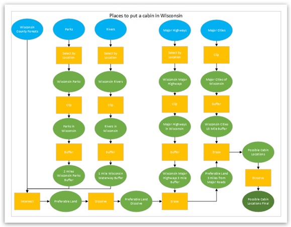
I used these following steps to create the following image.

Task 1: Download 2010 Census Data
I started by needing to download the 2010 Census data for the total population from the U.S. Census Bureau online.  To do this I opened up a web browser and navigated to the U.S. Census Bureau Fact Finder Website: http://factfinder2.census.gov/faces/nav/jsf/pages/searchresults.xhtml?refresh=t.  By using an Advanced Search I was able to narrow my search to select my data set of total population.  I selected my search through the following pathway, Topics, People, Basic Count/Estimate and then Population Total.  I then had to select my geography and I selected counties and then selected County 050.  I choose the state of Wisconsin and All Counties within Wisconsin.  With my search results I downloaded the variable P1 for TOTAL POPULATION from the 2010 SF1 Dataset. To access the files they had to be unzipped in Windows Explorer and saved the tabular data file as a MS Excel file (Excel Workbook file).       

Task 2: Download the shapefile for the WI census data
I next needed to download the shapefile for the Wisconsin census data.  I returned to the U.S. Census Fact Finder Website and under my Geographies search option I went to the Map tab and downloaded the map in the spatial data format of a shapefile.zip.  I unzipped these files in Windows Explorer.

Task 3: Join the data together
Next, I needed to join the shapefile with the Total Population data.  I added the shapefile of the Wisconsin census data and the P1 table to a data frame in Arcmap.  I joined the shapefile in the table of contents to the P1 table using the attribute common field of Geo_ ID to base the join on.  I exported the data to make the table join permanent in a new feature class.

Task 4: Map the data
I next started to construct my final map of the data.  I opened a blank map in ArcMap and changed the orientation to landscape.  I opened up my newly exported feature class in the data frame.   I changed the symbology of the feature class to quantities and graduated colors.  I set the value to D001_new, which I created in the attribute table by creating a new field and using the field calculator to populate the new field with D001 data.  The D001 data is the population per county data from the U.S. census.  In the symbology tab I also set a graduated color scheme and set the labels to 3 significant figures with thousands separators. 

Task 5: Map a variable of your choice
I wanted to add a second map displaying a different variable from the data available through the U.S. Census.  To do this, I returned to the census website and left my search as Wisconsin counties but changed my variable to Housing Units.   I downloaded the 2010 SF1 100% data from the H3, Vacant Housing Units, variable.  I unzipped these files in Windows Explorer and checked the Excel files to make sure there were no extra rows in the data and if there were I deleted the row.  I lastly saved the file as a MS Excel file.  I opened up my Vacant Housing Units data and the U.S. census shapefile for Wisconsin counties.  I joined and exported the tables based on the Geo_ID field.   I opened the new feature class in the data frame and changed the symbology to quantities and graduated colors.  I set the value to D003 (vacant housing units) and normalized the data by D001 (total housing units).  I set the labels to 2 significant figures and set the labels to percentages.    

Task 6: Build a layout
I put a lot of work into constructing the final map layout.  In the ArcMap window that I was previously working with in tasks 3 and 4, I created a second data frame.  I named the previous one "Population" and the new one I named "Housing".  In the housing data frame I added the feature class I created in task 5.   I set both data frames in Arc Map to the same size by using rulers and guides.  In each data frame I added the base map World Light Gray Base with no reference.  I zoomed in and set the map scale to a proper size to maximize the data frame size and include the whole state of Wisconsin in the frame.  I added boarders around each data frame.  I added titles, legends, scales, and north arrows to both data frames.  I edited the titles of the feature classes to make them more comprehendible.  I cited my sources and listed myself as the cartographer and included the date.  I made final touches to make sure the layout was even and visually pleasing and exported the map as a JPEG. 

Task 7: Create a web map
I started with the image created above and saved the image twice, each time under a different name so I had two copies of this image.  I then, in one of the saved copies of the image, deleted the County Housing Vacancy map data frame so I only the County Population data frame was present.  In this section I only downloaded one data set, County Population, to the web map.  I switched my ArcMap document to from layout view to data view.

Log into ArcGIS Online from ArcMap
I signed into my ArcGIS Online Account through the ArcMap window.  I went to File, Sign In, and chose to sign in with the University of Wisconsin Geography & Anthropology Organization account, and opened up with in that my University of Wisconsin-Eau Claire personal account.     

Create a feature service from an ArcMap document
To publish my map document to the ArcGIS Online server I needed to create a feature service from the ArcMap document.  I started by going to File, Share As, Service, and selecting Publish as a service.  I connected with My Hosted Service of UW-Eau Claire- Geography and Anthropology.  I also created a service name with no spaces.  When the Service Editor window opened up I changed the Capabilities from Titled Mapping to Feature Access.  I opened the Item Description tab and added a summary, tags, and description of my service.  Under sharing I selected to share my service with the UW-Eau Claire-Geography and Anthropology ArcGIS group.  In Service Editor I used the Analyze option to check my map document for errors.  When that checked out I published my service.   

Create a web map from my feature service
I opened a Google Chrome browser window and navigated to https://www.arcgis.com/features/.   I signed in with UWEC as my enterprise account and then my own account login credentials.  I went to the My Content tab on the main ArcGIS Online menu.  I located the feature layer I had made and selected the add layer to map option.  This opened an ArcGIS Online geobrowser with my service displayed in an ArcGIS Online map.  Under Content, I selected a three dot icon which allowed me to select the Configure Pop-up option.  In this new window I changed the title to "Population per county".  In the Configure Attributes window I selected for the map developer to only display the {NAME} and {POPN} attributes on the pop-up window.  I changed the alias of NAME to County and POPN to Population.  I saved the pop-up and gave my web map an appropriate title, tags and summary.  I save the web map and in the My Content window selected to share my web map with the UWEC Geography organization.        

Results:

Figure 1 shows the population per county in Wisconsin in the map in the left and the map on the right shows percent of the total housing units that are vacant per county in Wisconsin.  This map was created through the steps listed out in tasks 1 through 6 above.  The data used in this figure is from the 2010 U.S. Census.  The image on the left shows that the most populated counties are located in southeastern Wisconsin.  This image also shows that the counties with the lowest populations are located in northern Wisconsin.  The image on the right shows that the counties with the greatest percentage of total housing units that are vacant are located in northern Wisconsin.  This image also shows that the counties with the lowest percentage of total housing that are vacant are located in southeastern Wisconsin.  These graphs aid in determining that northern Wisconsin does not have lower population levels per county because of a lack of housing units, because the image on the right shows that there are numerous housing units vacant in northern Wisconsin.  People are making a deliberate choice to not populate northern Wisconsin.

Figure 1

This web map was created in task 7 of this lab. 


Sources:
U.S. Census Bureau; 2010; Wisconsin County Shapefile; Census Tables P1 and H3; generated by Shannon Rose; using American FactFinder; <http://factfinder2.census.gov>; (4 April 2016).


ArcGIS.com News. N.p., n.d. Web. 04 Apr. 2016. <http://www.arcgis.com/home/>.

Thursday, March 10, 2016

Lab 1: Base Data


Introduction: 

Clear Vision Eau Claire is a countywide leadership organization with a goal of developing a collective goal for the future of Eau Claire.  Clear Vision Eau Claire in 2012 formed a public-private partnership between local developers.  These developers were the University of Wisconsin-Eau Claire and the Eau Claire Regional Arts Center.  This partnership is working on developing a new development at the confluence of the Chippewa and Eau Claire Rivers.   This new development has been named the "Confluence Project".  This project will create a new community arts center, university student housing, and a commercial retail complex located in downtown Eau Claire.  

In this lab, I was posing as an intern for Clear Vision Eau Claire to prepare base maps for the Confluence Project.  The goal of this lab was to utilize various data sets used in public land management, administration, and land use methods to prepare the base maps.


Methods:

I learned many valuable new skills while completing this lab.

  • I learned how to find the rules of a topology.  It is found under the rules tab of the Topology Properties.  You can read through the rules and get a description of what the rule does.
      • Example: Parcel_Line Rule: must not have dangles, a line from one layer must touch the lines from the same layer at both endpoints. An endpoint where the line does not touch another line is an error.
  • I learned how to digitize land sites on ArcMap using the editor toolbar and snapping toolbar.  
    • Digitizing is the process of converting shapes on a paper map to a digital map layer by entering vertices.  This is a valuable technique because it is one of the main ways data is generated.  
      • Example: In this lab the proposed site for the Confluence Project needed digitizing.  The editor toolbar and snapping toolbar were used to digitize the polygons of the proposed site by adding vertexes.  Exact steps are given in step 4 below.
  • I learned how to utilize basemaps and how helpful they can be.  Basemaps provide essential outlines that can be used for plotting and the presentation of specialized data.  
  • I learned how to utilize data from various websites and government reports.  These sources have valuable information that can be added to improve maps.  
      • Example: Using the City of Eau Claire mapping services website to access city parcel information such as, parcel number, owner and other important data.  I also accessed legal descriptions of the land parcels.   


These are the steps I followed to create the following image.

    1. To start I set the paper layout to landscape and size 11 X 17 inch.  
    2. I added 6 data frames and labeled each with an appropriate title matching the set of data that would be entered in the frame.  I used text boxes to insert the titles.  I properly used rulers, grid lines, and guides with the snap to grid lines and guide lines tools to align the 6 data frames and titles in a professional manner.    
    3. Before I started adding any real data to the data frames, I first added the World Imagery Basemap to all of the data frames.  I also zoomed into the location of the Confluence Project on the maps.  
    4. The first piece of data I had to compile was the Proposed Site feature class.  To do this I opened a blank map in ArcMap and created a new blank geodatabase and a blank feature class.  I set the coordinate system to the same as the other databases holding the data for this project, the Eau Claire County Coordinate system.  I added the World Imagery Basemap, and activated the editor toolbar.  I added the parcel_area and proposed site feature classes and changed the pacel_area symbology to a hollow symbol with a bright outline.  Using the start editing feature on the editor toolbar I selected start editing for the proposed site feature class.  I then activated the snapping toolbar and selected for End Snapping and Vertex Snapping.  Using the legal outline of the proposed area as a guide I started digitizing the proposed area by using the polygon tool and clicking the boarder boundaries of the proposed area supplied by the parcel_area feature class.  Each click created a new vertex and I continued to trace the boarder of the locations.  Once both land parcels were digitized I saved my edits and selected to stop editing.  I closed my blank map in ArcMap and returned to my Confluence Project map.       
    5. I added the newly created Proposed Site feature class to each data frame and gave the polygon feature a bright red color so it could be easily distinguished.  For the maps that would need to be in a more zoomed out frame view I added label callouts allowing the proposed site to stay visible.  
    6. I added relevant data to each data frame.
        • Civil Divisions: I added the Eau Claire county boundary and changed the symbol to a light grey outline with a hollow inside.  I also added the civil divisions feature class.  
        • Census Boundaries: I added the BlockGroups and Tracts Group feature classes.  The Tract Group was added allowing it to be on top of the BlockGroups.  I set the BlockGroups to only allow data to two significant figures and gave it a graduated color scheme.  
        • PLSS Features: I added the PLSS feature class and made it hollow with a bold boarder. 
        • Eau Claire City Parcel Data: I added the parcel_area, centerlines, and water feature classes to the map.  I gave the parcel_area feature class a hollow symbol with a bright colored outline.  
        • Zoning: I added the zoning_areas feature class.  I symbolized the data using unique values based on zoning classes.  I used zoning codes to group similar data into six groups: commercial, central business district, industrial, public properties, residential, and public properties.  I also added the centerlines feature class. 
        • Voting Districts: I added the voting districts feature class for the city of Eau Claire.  I also labeled the voting districts by their ward number and gave the labels a halo.    
    7. I gave all polygon feature classes that were not turned into hollow symbols a transparency value so that the basemap could still be referenced.  The only polygon feature class to receive no transparency was the Proposed Site feature class.  I also adjusted all line feature classes and hollow symbols to the proper thickness.  I worked with color schemes to make the map visually appealing and easily interpreted.  
    8. Once all of the data was added to each data frame, I adjusted all of the data frames to appropriate scales to be able to effectively view the data in the frame.  
    9. I then added scale bars to all of the maps and legends to the maps they applied to.  I made sure the scales were in appropriate measurement increments and that the legends did not have any abbreviations and were neat and could be easily interpreted.  I made any adjustments that needed to be made.  I then arranged the scale bars and legends so that they would not distract from the maps.    
    10. To finish the map I sourced and dated where I got all of my data, City of Eau Claire and Eau Claire County 2013.  I also listed myself as the cartographer.  


Results:
Figure 1

The results for Figure 1 show that the Confluence Project will be located in the city civil division of the Eau Claire County.  The project is with in the census boundaries where the population per square mile is 3,600 to 5,000 people.  The location of the project falls with in the Eau Claire township according to the Public Land Survey System.  There are 18 townships in Eau Claire County.  The city of Eau Claire exists the majority in Township 27 North Range 10 West.  The plots of land where the Confluence Project is located occupies two sections of the 36 sections of the township.  The Confluence Project occupies two Eau Claire city land parcels.  The land designated for the Confluence Project is apart of the central business district.  The two land parcels are separated by a patch of land that is public property.  The Confluence Project is in voting district 31.  The patterns that can be found on the map show that the land parcels for the project are located in the heart of the business district of the City of Eau Claire.

Sources:

"City of Eau Claire, WI WG Xtreme." City of Eau Claire, WI WG Xtreme. N.p., n.d. Web. 09 Mar. 2016. <http://eauclairecitywi.wgxtreme.com/>.

"Foundation, What, Place, Confluence." Foundation, What, Place, Confluence. N.p., n.d. Web. 09 Mar. 2016. <http://www.uwec.edu/Foundation/what/buildings/confluence.htm>.

Hemstead, Brenda. "PLSS- Legal Descriptions PLSS." PLSS - Legal Descriptions PLSS. N.p., 18 Mar. 2015. Web. 09 Mar. 2016. <http://sco.wisc.edu/legal-descriptions.html>.

Lippelt, Irene D. UNderstanding Wisconsin Township, Range, and Section Land Descriptions. Rep. no. 0375-8265. Madison: Wisconsin Geological and Natural History Survey, 2002. Print. Educational Ser. 44.

"Mapping Services." City of Eau Claire, Wisconsin: N.p., n.d. Web. 09 Mar. 2016. <http://www.eauclairewi.gov/departments/public-works/engineering/mapping-services>.

"You Have a Role to Play in Building Eau Claire's Future." Community for the Confluence. N.p., n.d. Web. 09 Mar. 2016. <http://communityfortheconfluence.org>.